To understand the full benefits of EMODnet, users are kindly asked to describe how EMODnet supports them in their daily work and activities.
If you have developed an application using EMODnet products that you would like to share with us or if you use EMODnet data for other purposes, submit your use case by contacting secretariat@emodnet.ec.europa.eu.
The Horizon Europe MSP4Bio project used EMODnet multidisciplinary marine in situ data, including from Bathymetry, Biology and many other thematic data, to inform an Ecological-Socio-Economic (ESE) management framework used for science-based MSP to safeguard and restore biodiversity in a coherent European MPA network.
Croatian Geological Survey used EMODnet Geology, Bathymetry and Seabed Habitats data to develop the seabed substrate and geology maps within a project that aims to map the marine habitats of the coastal area of the Adriatic Sea up to a depth of 40 m and up to 200 m in protected areas.
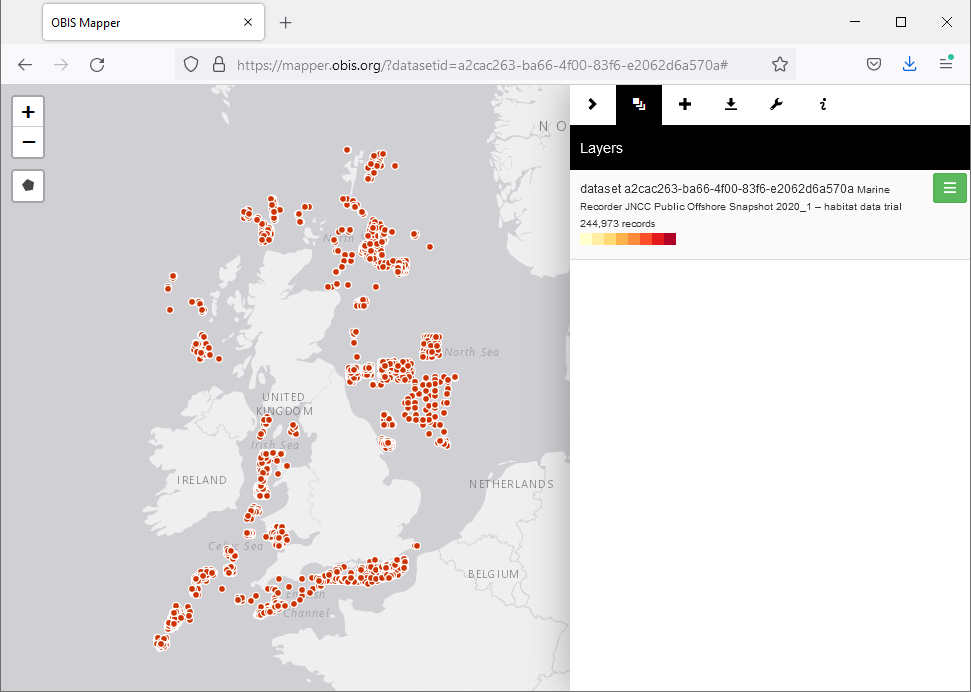
Collaboration between EMODnet Biology, EMODnet Seabed Habitats and OBIS (Ocean Biodiversity Information System) has facilitated richer dataset publication and ensured the greatest volume of high-quality species and habitat data are available for reporting, assessments and informed decision making.
A joint Copernicus Marine and EMODnet data catalogue for the Marine Strategy Framework Directive (MSFD) has been developed. It gathers all relevant marine data products from Copernicus Marine Serviceand EMODnet for all the MSFD descriptors (except Descriptor 4) in the Baltic Sea.
Outcomes: Users were able to apply a marine ecosystem services model to the Lithuanian sea to identify areas where anthropogenic impacts most greatly affected valuable fish provisioning areas and cultural coastal regions. Authors stated the information was particularly useful for regional authorities to apply an ecosystem-based management approach to marine spatial planning.
How EMODnet Seabed Habitats helped the user: EMODnet provided best available and free substrate data for the Lithuanian portion of the Baltic Sea.
The European Commission (EC) supports policy development and implementation within the EU, working to support the EU’s framework for marine environmental protection. The Commission is also responsible for ensuring that member States apply EU environmental law correctly, helping them to comply with agreed legislation, as well as following up on complaints from citizens and non-governmental organisations.
Outcomes: Users were able to apply a demonstrator tool able to map the Risks of Cumulative Effects (RCE) of different pressures, using benthic habitats within France as an example.
How EMODnet Seabed Habitats helped the user: Coverage of benthic habitats was sourced for the entire French Exclusive Economic Zone.
This study was published by a group of authors, including representatives from a range of universities and research organisations. The lead author is the University Technology Sydney’s fish ecology lab, which aims to provide novel research to inform on the sustainability of the oceans and their fish populations. They actively engage in public debate on a wide range of issues affecting the marine environment, and also act as a hub for student research training. Their studie
Users identified the main areas where disturbance from bottom-contact fishing was predicted to cause the most significant impact to benthic marine habitats. This work fed directly into the OSPAR Intermediate Assessment (2017) with future implications towards the Marine Strategy Framework Directive assessments.

 Ozren Hasan; b) Slobodan Miko, c), d), e) Ozren Hasan, f) Ante Žuljević")
 and the relation to the seabed substrates (EMODnet Geology).")