Marine habitat mapping of the Croatian part of the Adriatic Sea
The user organisation
Croatian Geological Survey Hrvatski geološki institut | Croatian Geological Survey is the largest research institution in the field of geosciences and geological engineering in Croatia. Collected and interpreted geological data is the basis for numerous national projects concerning water supply, water protection, soil protection, urban planning, and traffic planning, as well as mineral resources and environmental protection. The marine geology and palaeolimnology group within the Croatian Geological Survey consists of six scientists as permanent staff, three PhD students, and two chemists as permanent staff working in the laboratories. A group covers geological, geochemical, paleontological, mineralogical, and sedimentological aspects of the marine realm, as well as acoustic and geophysical surveys, analyses, and interpretations.
Challenges faced by the user
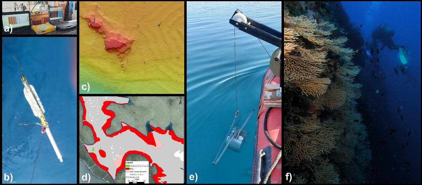
The Ministry of Economy and Sustainable Development awarded a consortium comprising several institutions (Oikon Ltd. – Institute of Applied Ecology, Institute of Oceanography and Fisheries, Faculty of Geodesy, Institute for Marine and Coastal Research, Croatian Geological Survey, Croatian Hydrographic Institute, and Faculty of Electrical Engineering and Computing) a bid for “Mapping of the coastal and demersal marine habitats in the coastal sea of the Republic of Croatia and demersal marine habitats in the Croatian continental shelf”. The aim of the project is detailed mapping of the marine habitats of the coastal area of the Adriatic Sea up to a depth of 40m and up to 200m in protected areas. Methods used in the detailed mapping comprise acoustic geophysical methods (multibeam echosounder and side-scan sonar), diving, and ground truthing (grab sampling and drop-down camera transects). The epicontinental part of the Croatian Adriatic Sea will be mapped or modelled in less detail. Besides mapping, project objectives include planning, revision of the existing National classification of marine habitats, and data collection, analysis, and validation. The gathered data and information will be stored in custom-made databases. Areas not covered in detailed mapping will be modelled based on in-situ sampling and validation. The project, funded through the Operational programme Competitiveness and Cohesion 2014-2020 based on the Council Directive 92/43/EEC, is under implementation from 2021-2023. Mapping will cover 51% of Croatian territorial sea.
A large area to cover (at least 16.054,29 km2, or 51% of the coastal sea of the Republic of Croatia) posed a challenge for the consortium due to a very short implementation period. A demanding project included a need for detailed mapping of coastal and demersal marine habitats up to the depth of 40 m, all areas of the ecological network Natura 2000 up to the depth of 100m, and all protected areas up to the depth of 200 m. To timely and successfully plan and afterwards execute the project, it was of profound help to use the available data from, among others, EMODnet Geology, EMODnet Bathymetry, and EMODnet Seabed Habitats.
EMODnet services used
The Croatian Geological Survey is in charge of the development of the Seabed Substrate and Geology maps within the project. Therefore, they consulted the Seabed Substrate and Sea-floor EMODnet Geology data products available from the EMODnet web services (EMODnet Map Viewer) . The available data is very useful for survey planning as well as for proofing and comparing the collected data. In addition to the Seabed substrate and Sea-floor data products, the EMODnet Coastal Behaviour and EMODnet Coastal Type web services were also of profound importance during the planning and execution of the project, as the focus of the project is on the coastal area. Furthermore, the downloaded EMODnet Seabed substrate data will be used for modelling the parts of the Adriatic that are not covered by detailed mapping with geophysical methods (multibeam and side-scan sonar).
During the planning phase of the project, EMODnet Bathymetry’s Digital Terrain Model for the Adriatic Sea was used to better define the areas of detailed investigation. Additionally, EMODnet Seabed Habitats’ broad-scale seabed habitat map for Europe (EUSeaMap) was consulted both during the planning and employment phases of the project to get a better overview of the Eastern Adriatic Sea habitats within the scope of the project.
Impact of EMODnet
EMODnet data enabled better planning and organization of the different project phases, which significantly reduced the time of its implementation. The EMODnet maps will further assist during the final phases of the project. The project was carried out in cooperation with different partners who gained insights into the importance and versatility of the available datasets on the EMODnet Portal.
The new marine data set and maps for the Croatian part of the Adriatic Sea will be available in 2024, on the website of the Institute for Environment and Nature at the Ministry of Economy and Sustainable Development .
Media