Windfarm Siting Challenge
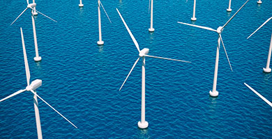
The aim of the Wind Farm Siting challenge was to assess whether the data currently available across and near territorial boundaries in the North Sea is appropriate in undertaking the preliminary assessment required to identify potential new wind farm sites. The challenge was undertaken from the perspective of a wind farm operator assessing suitable locations for offshore wind sites. As such it took into consideration factors that affect generating capacity, construction and maintenance, potential environment impacts, and current sea-use.
The wind farm site selection exercise was successful in identifying potential sites across the two study areas specified in the project brief. Limitations were expected for both of the study areas as the territorial boundaries between Norwegian, UK, Danish, German and Dutch waters (Area A) lie in the middle of the North Sea to the east of Dogger bank, a long way offshore in relatively deep water, while the boundaries where UK, Dutch and Belgian waters meet and UK, Belgian and French waters meet lie close together towards the eastern extent of The Channel (Area B) in an area of heavy sea-use.
The method used for wind farm siting was adapted from an approach used for site selection for much smaller license areas. Using this approach, it was possible to make an indicative assessment of potential areas for wind farm licencing using available data accessible online. A more detailed evaluation would need to be undertaken through a full environmental assessment using commercial data products combined with a regime of site specific data gathering to make a more accurate evaluation of site potential, followed by a phase of focussed field work and sampling of seabed sediments and underlying geology, wave and wind regime and ecological studies to gain a more accurate picture of site characteristics.
The final output of the challenge and lessons learnt was outlined in detail in the challenge’s Data Adequacy Report (DAR), which was delivered in April 2015. The outcomes have been presented:
- at the project Expert Panel meeting (after which comments and amendments were made to the report);
- to the EMODnet steering committee meetings;
- at an EMODnet checkpoint meeting; and
- to a wider stakeholder audience at a conference entitled “Blue Growth An expanding role for GI and GIS in the marine and maritime sectors” held on 20th May 2015, in London, UK
Click here to view the Wind Farm Challenge Data Adequacy Report [pdf]