Marine Protected Areas
 Within the Arctic, different types of national Marine Protected Areas (MPAs) have been established under national legislations. The Arctic covers a number of seas under national jurisdictions as well as areas beyond national jurisdictions (high seas). High sea MPAs, known as Vulnerable Marine Ecosystems (VMEs), have been established by Regional Fisheries Management Organisations (RFMOs). In this challenge we present an overview of all these types of MPAs. Additionally, we evaluate the current MPA network in terms of how representative and coherent it is, and how likely MPAs are to be affected by climate change.
Objectives of the challenge
1. Gather data to compile a (geographical) database of the Marine Protected Areas within the Arctic (Phase I)
2. IUCN classification of MPAs (Phase I)
3. Produce an analysis of Coherence of the MPA network (Phase II)
4. Asses the (potential) impact of Climate Change on MPAs (Phase II)
Main results
Arctic MPAs and IUCN classification (Phase I)
In this challenge the network of Arctic MPAs was analysed. Data on MPAs were obtained from various sources, the most comprehensive being the World Database on Marine Protected Areas. In total, 492 marine protected areas were included.
EU Natura 2000 areas or Vulnerable Marine Ecosystems (VMEs) are present in this part of the world. Of the 333 records in the OSPAR database, only eight MPAs were inside the Arctic region, and these were included in the analysis. In total, 11 Norwegian MPAs and five proposed Norwegian MPAs were included. For the USA, 38 additional MPAs published by NOAA were included, including a lot of fishery closures. The network of EBSAs was also included (see Figure 1). An inspection of Greenland, Russian and Canadian (from DFO) data sources did not reveal any MPAs not listed in the Word database.
The resulting data set of MPAs is available in the geoviewer. The geoviewer will also allow for comparisons of the MPA network with habitat maps and fishery intensities.
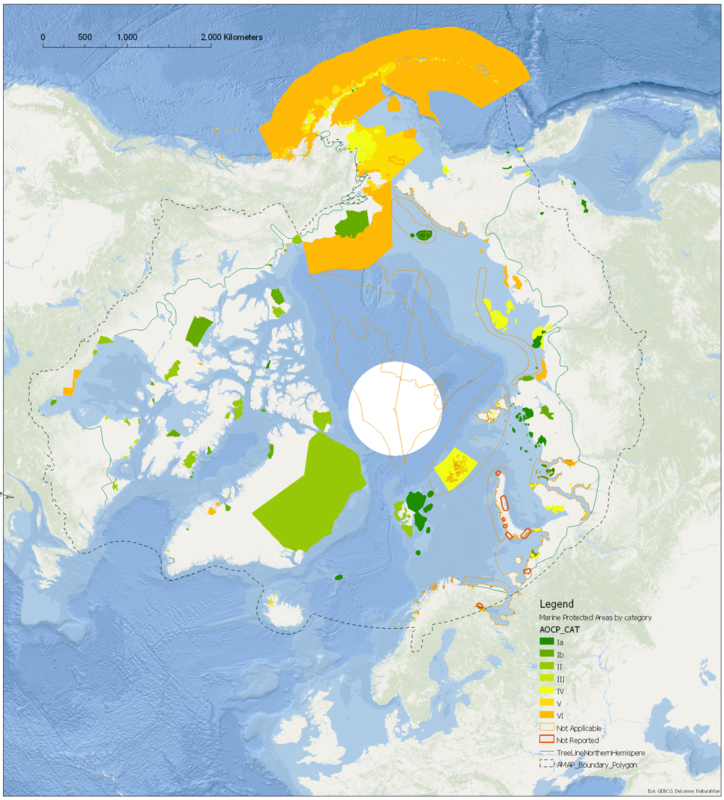
Figure 1. MPAs in the Arctic classified according to the IUCN categories (final results, July 2016). The IUCN categories are: Ia - Strict Nature Reserve, Ib -Wilderness area, II - National Park, III - Natural Monument or feature, IV - Habitat/species management area, V - Protected landscape/seascape, VI -Protected area with sustainable use of natural resources (for details, see the IUCN classification). Not Applicable: the IUCN Management Categories are not applicable to a specific designation type. This currently applies to World Heritage Sites and UNESCO MAB Reserves. Not Applicable also applies to a site that does not fit the standard definition of a protected area (PA_DEF field = 0). Not Reported: for protected areas where an IUCN category is unknown and/or the data provider has not provided any related information.
Analysis of Coherence of the MPA network (Phase II)
MPA information does not include specifics on the species and/or habitats that justify designation as an MPA and does not present specific species that are protected by the MPA. A selection of species was therefore made to further study the coherence of MPA networks. While the available data was sufficient to complete the coherence analysis, the process was complicated by the fact that the species data had to be obtained from different sources. This meant that the methodology had to be altered to achieve comparable results.
The Coherence analysis resulted in identification of a single threatened habitat: Sea ice. Sea ice is an essential habitat for a number of Arctic species and is only to a very small extent included within current MPA boundaries.
The (potential) impact of Climate Change on MPAs (Phase III)
The initial plan was to assess the effects of climate change in the Arctic on both abiotic factors (melting ice, fresh water input and acidification) and ecological factors (changes in primary production, shifts in species ranges, species distribution and abundance, loss of habitat, change in migratory patterns, etc.) (Soto, 2001; Roessig et al., 2004) at a high level of detail per MPA (specific species, stressors and their magnitude). Unfortunately, this analysis could not be completed, because:
With the lack of information available to the project, this challenge could not be completed in its intended fashion.
The outcome of the Coherence analysis is that sea ice is a threatened habitat within the Arctic and one that is clearly negatively impacted by Climate Change.
Problems and gaps
- Data availability: the IUCN offers data on species distribution on their website. While we made multiple requests for 14 sets of distribution data for analysis within Task 3, we received no reply.
- Language problems: information on Russian MPAs was available on multiple websites, so that by compiling different texts we could form an impression of the status of the MPAs. Texts in most Scandinavian were translatable and for a lot of areas information in English was available as well.
Lessons learned
- The World Database on Protected Areas contained 90% of the MPAs, but is not complete.
- We think the current MPA database developed in this project is relatively complete.
- Geographical Information Systems (GIS): maps need to be projected to a polar projection, because otherwise select-by-location operations give unexpected results. For example, when searching for an area 50 km away from a certain point, a non-polar projection gives incorrect results otherwise.
References
- WPDA: http://www.protectedplanet.net
- Norway - Miljødirektoratet.NO http://www.miljodirektoratet.no/no/Tjenester-og-verktoy/Database/ and http://kartkatalog.miljodirektoratet.no/Map_catalog_Dataset_overview.asp
- USA - NOAA: http://marineprotectedareas.noaa.gov/dataanalysis/mpainventory/ Download links: [Date accessed: 20151222]
- Canada - Fisheries and Oceans Canada (DFO)
- Webpage with an overview of MPA and Areas of interest [Date accessed: 20151222]
- Greenland - Naalakkersuisut = Government of Greenland (website) [Date accessed: 20151222] http://naalakkersuisut.gl/en/About-government-of-greenland/Travel-activities-in-remote-parts-of-Greenland/Publications has downloads for PDFs for National Parks, Protected Areas and Ramsar Areas.
- Iceland - Umhverfisstofnun or Environment Agency of Iceland (http://www.ust.is/the-environment-agency-of-iceland/. [Date accessed: 20151222]
- Russia: Wild Russia [Center for Russion Nature Conservation]. [Date first accessed: 20151222]
- OSPAR MPA Network - http://mpa.ospar.org/home_ospar
- RAMSAR sites - http://www.ramsar.org/sites-countries/the-ramsar-sites
- UNESCO MAB-sites (http://www.unesco.org/new/en/natural-sciences/environment/ecological-sciences/biosphere-reserves/europe-north-america/)
- World Heritage Sites (http://whc.unesco.org/en/list)
- EBSA (Ecologically or Biologically Significant Marine Areas) (https://www.cbd.int/ebsa/about)